History

South Ferriby’s Heritage and History 

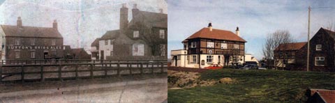
South Ferriby has a fascinating history. The location of the village, just where the Wolds meet the Humber has meant that since prehistoric times it has had a strategic importance.

The name of course correctly suggests it was a ferry terminal and in fact ferries ran from Ferriby Sluice until the first World War.

South Ferriby Origins

South Ferriby as the name suggests is defined as ‘The farmstead or village beside the ferry’. South Ferriby has through the ages been known as the following:- Ferriby, Ferraby, Ferribi, Ferebi, Ferya By, Ferrebe, North Ferebe, which is shown on an old map dating from 1610 and South Ferraby (in 1842). It is South in raltionship to North Ferriby which is located on the opposite bank of the River Humber.

The Doomsday Book (1086) referred to the village as “Ferebi”.

Other names – for the village include Suth Feriby

The name – can be translated to ‘The farmstead or village at the ferry’. It is South in contrast to North Ferriby which is located on the opposite bank of the River Humber. -by – farmstead, village – (Old Norse – by)

South Ferriby Publications

We are very fortunate in having in the village a number of enthusiastic historians and extracts from their publications and photograph collections can be viewed on this page.

Copies of the parish registers are held on microfiche at Scunthorpe Library and cover:

Baptisms 1538 to 1911

Burials 1618 to 1991

Marriages 1639 to 1971

Now and Then

Many more photographs can be viewed on our gallery page.

If you have any additions for the history page please contact the clerk May open an email client if one is installed.

Humber Keels and Sloops

The Humber Keel and Sloop Preservation Society are a Society of volunteers who preserve and sail two rare historic Sailing Vessels which can often be seen sailing on the Humber.

Their mission is to preserve two Historic Sailing Vessels, the Humber Keel ‘Comrade’ and the Humber Sloop ‘Amy Howson’, which make part of our local Maritime Heritage, and to continue to sail them on their home waters.

All photographs kindly provided by the Humber Keel and Sloop Preservation Society.
http://www.keelsandsloops.org.uk/ Opens in a new window

Population History

YEAR – POPULATION

1801 – 280

1811 – 420

1821 – 453

1831 – 500

1841 – 542

1851 – 580

1861 – 573

1871 – 721

1881 – 733

1891 – 638

1901 – 738

1911 – 725

1921 – 736

1931 – 701

1941 – N/A

1951 – 696

1961 – 663

1971 – 607

1981 – 619

1991 – 614

1891 Surnames (A – Z)

Allison, Altoft, Anderton, Andrew, Andrews, Asgerby, Austin.

Bachelor, Barker, Barley, Beacock, Beedan, Benson, Birkitt, Briggs, Brown, Bryan, Bullivant, Butler.

Carlisle, Castle, Clark, Cliff, Cook, Cousins, Cressey, Crow.

Daw, Dawson, Dent, Dinsdale, Downs, Drury, Dunn.

Ellis, Evendon.

Farrow, Fidgett, Firth, Fowler, Franks, Frow, Fysh.

Gibson, Gilliatt, Grasby, Green, Gunson, Guy.

Hall, Hanson, Harvey, Hatcliff, Hatfield, Havercroft, Hebblewhite, Heslam, Hewson, Hildreth, Holdwith, Holland, Holmes, Howell, Howells, Howson, Huteson.

Jacklin, Jackson, Johnson, Jones.

Kellick, Killick, King, Kirk, Kitchen.

Lamming, Laverick.

Mallty, Marten, Martin, Master, Mathews, Melton, Milner, Moment, Morris, Moxon.

Oglesby, Osgerby.

Parkinson, Pocklington.

Rack, Revell, Reville, Richardson, Robinson.

Sammons, Sargant, Slater, Smith, Sobey, Spawforth, Stamford, Stephens, Such, Sumpter, Sweeting.

Taylor, Thompson, Tindale, Todd, Tomblin, Twidale.

Underwood, Usher.

Vessey.

Waddingham, Walker, Walton, Wardle, Watson, Welch, Westerdale, Wilkinson, Wills, Wilson, Wood, Wrightswan

Historic Map of South Ferriby

This historic map has been supplied by www.old-maps.co.uk Opens in a new window

A historic map showing South Ferriby

Click here to view a large version of the map (PDF format). Opens in a new window

© and database right Crown copyright and Landmark Information Group Ltd
(All rights reserved 2006)

Clerk

Ann Boulton
21 Hallam Close
Barrow upon Humber
DN19 7FD

Telephone

07592 66 60 58